
Warangal Airport Master Plan: AAI Layout & Technical Analysis
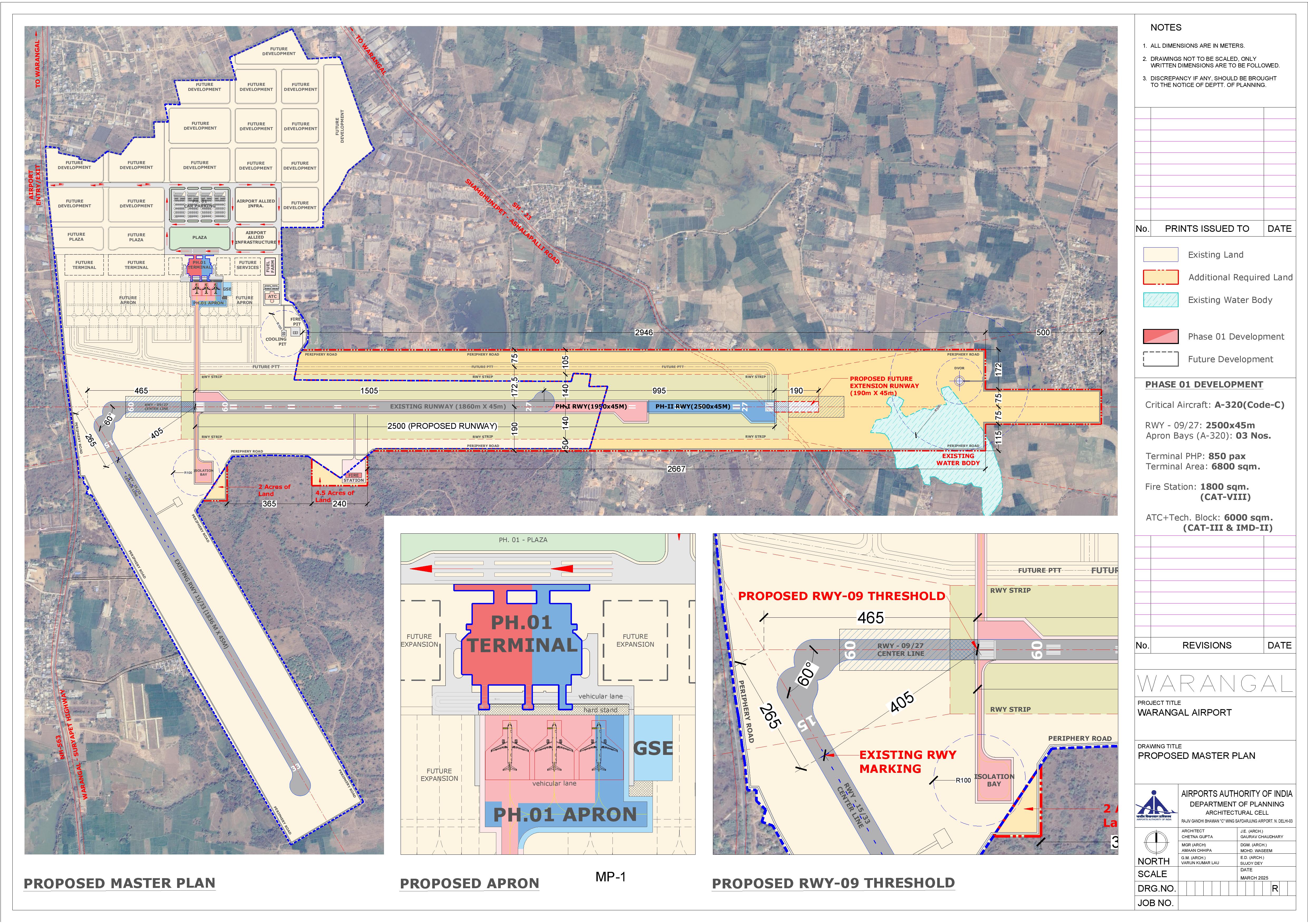
An independent technical analysis of the proposed Airports Authority of India (Department of Planning, Architectural DPU) Proposed Master Plan for Warangal Airport (Mamnoor Airport) (Mamnoor, Warangal, Telangana 506005). GPS Coordinates: 17.91406431619069, 79.59960335949711. This plan establishes the spatial layout, runway lengthening to 2,500 meters, Airbus A-320 apron stands, and the 6,800 sq.m modular passenger terminal.
Warangal Airport (Mamnoor Airport)
Postal Address: Mamnoor, Warangal, Telangana 506005, India
GPS Coordinates: 17.91406431619069, 79.59960335949711 (17°54'50.6"N 79°35'58.6"E) · Elevation: 285 m AMSL
Enables full scheduled domestic commercial airline operations (IndiGo, Air India, Akasa Air) beyond regional turboprops.
Existing 1,860m strip upgraded with a proposed future extension allowance of 190m × 45m for ultimate operations.
Integrated with dedicated Ground Support Equipment (GSE) holding areas and vehicular movement lanes.
Single-level modular passenger terminal building with symmetrical land reservations for future terminal expansion wings.
Rapid intervention appliance bays providing emergency coverage for high-density narrowbody jet operations.
Consolidated air traffic management facility with Indian Meteorological Department (IMD-II) automated weather radar.
Existing Land vs Additional Required Land (253 Acres)
The blueprint clearly establishes the land zoning using a standardized color-coded legend:
- Existing Land (Yellow Shading): The historical aerodrome property originally encompassing the Nizam-era airstrip and surrounding administrative lands.
- Additional Required Land (Orange with Red Stripes): The critical acquisition corridor extending eastward past the existing runway boundary. This 253-acre parcel was essential to expand Runway 09/27 from its historical 1,860m length to the full 2,500m length plus instrument approach lighting and runway end safety areas (RESA).
- Existing Water Body (Cyan Shading): The drawing shows an existing reservoir east of the runway. The AAI master plan engineers the runway strip and boundary wall around the northern margin of the water body, maintaining an ecological buffer and avoiding encroachment on natural hydrologic flow.
Runway 09 Threshold Offset, Isolation Bay & Historical Cross-Runway 15/33
The bottom-right inset "PROPOSED RWY-09 THRESHOLD" reveals intricate aerodrome geometric engineering:
- 465-Meter Threshold Shift: The Runway 09 operational landing threshold is positioned 465 meters inward from the western boundary to clear the approach obstacle limitation slope (OLS).
- Smooth 60° Periphery Road: A dedicated airport perimeter security road curves at a 60-degree angle around the Runway 09 threshold, providing uninterrupted security vehicle patrol without penetrating the runway end safety area.
- Dedicated Isolation Bay: An isolation parking bay with a dedicated turning radius (R=90m) is engineered south of the threshold, complying with BCAS and ICAO counter-hijack and emergency security protocols.
- Historical Runway 15/33: The blueprint depicts the faint centerline of the old diagonal airstrip (Runway 15/33, oriented 405m / 265m), confirming Mamnoor's historical cross-runway heritage from the 1930 Asaf Jahi era.
Terminal Concourse, 3 A-320 Stands & Ground Support Equipment (GSE)
The bottom-center inset "PROPOSED APRON MP-1" outlines the passenger terminal campus:
- PH.01 Terminal Building: Centered squarely on the apron with departure and arrival concourses. Flanked on both east and west sides by designated "FUTURE EXPANSION" plots to scale up passenger handling as passenger traffic grows.
- PH.01 Apron Layout: Accommodates 3 simultaneous Airbus A-320 (Code-C) aircraft parking positions with clearly marked pushback lines and vehicular clearance lanes.
- GSE Staging Depot: A dedicated ground support equipment staging area is positioned to the right of Bay 3, preventing ramp congestion during baggage loading, refueling, and aircraft pushback.
- PH.01 Plaza & Surface Access: Located north of the terminal, providing direct vehicular drop-off lanes, passenger pickup zones, bus bays, and pedestrian walkways connecting to the city access road toward Warangal city center.